


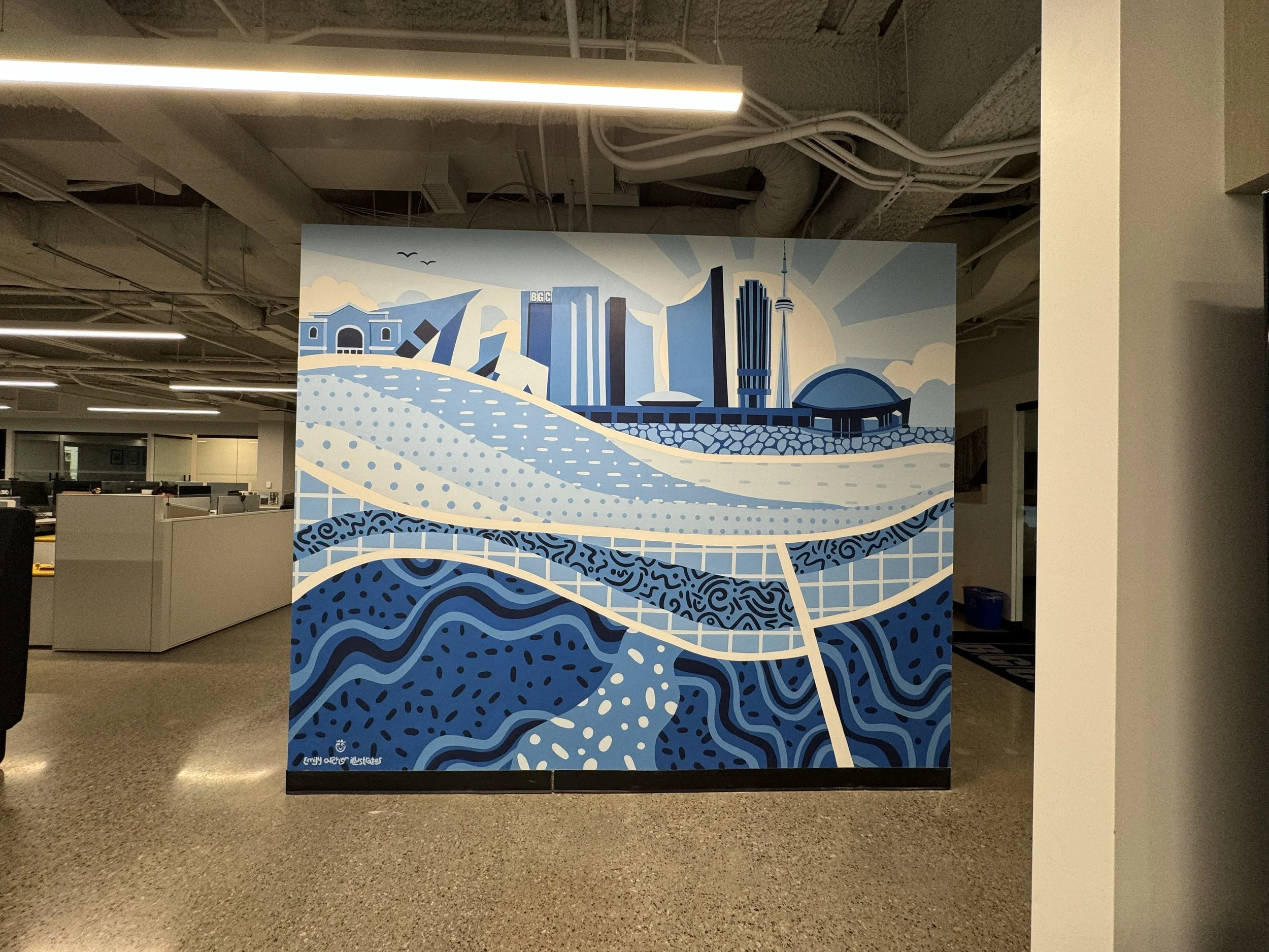
BGC Engineering Toronto mural
In geology and geotechnical engineering, cross-sections are a common visual tool used to convey subsurface information. What better artwork to represent a geotechnical engineering company than an illustrative cross-section of the city where the office is located? This piece draws on research about the geology of downtown Toronto, as well as standard methods for illustrating cross-sections and stratigraphy. The iconography representing each geological unit is loosely based on typical lithologic patterns found in stratigraphic columns, sections, or charts (“Lithologic Patterns,” 2006).

Toronto above and below, Acrylic paint on drywall, 121" x 98", 2024

Toronto above and below, Acrylic paint on drywall, 121" x 98", 2024

Toronto above and below, Acrylic paint on drywall, 121" x 98", 2024
Toronto above and below, Acrylic paint on drywall, 121" x 98", 2024

Toronto above and below, Acrylic paint on drywall, 121" x 98", 2024
Toronto above and below, Acrylic paint on drywall, 121" x 98", 2024
The bottom two-thirds of the mural depicts a typical geological cross-section of Toronto. The oldest unit, located in the southern (Grenville) portion of the Canadian Shield, consists of highly metamorphosed rocks resulting from orogeny (mountain building) and would have been fissured by frequent volcanic activity during that period (Remiz, 2012). Above this unit, separated by a thick white line indicating an unconformity, are sedimentary deposits from a time when southern Ontario was an inland sea, approximately 450 million years ago. These deposits include fossiliferous limestones, shales, and dolostones. Around this period, Pangea was breaking up, causing faulting in the geological record (Remiz, 2012). The youngest unit, also separated by an unconformity, consists of sediment deposits of till, sand, and clay from the last ice age, which ended about 12,000 years ago. The glaciers that covered the area eroded the underlying layers and left significant sediment deposits, which form the foundation of present-day Toronto (Remiz, 2012).
Unlike typical geological cross-sections, this mural features iconic Toronto buildings, including the Royal Ontario Museum, 121 King Street West (BGC’s Toronto office), City Hall, Sterling Tower (BGC’s former Toronto office), the CN Tower, and the Rogers Centre. The buildings are oriented from north on the left to south on the right, mirroring the orientation of the geological cross-section, based on Sharp (1980). Below the southern side of the buildings is an area representing the geology of the Anthropocene, when much of Toronto’s current shoreline was created through landfill (Old Toronto Series, 2021).
I encourage anyone interested in learning more about Toronto's geological history to speak with a geologist. They will be eager to share insights about approximately 4.5 billion years of fascinating history!

References
Lithologic patterns. (2006). In Federal Geographic Data Committee (FGDC-STD-013-2006; p. 37.1-37.3). Retrieved July 1, 2024, from https://ngmdb.usgs.gov/fgdc_gds/geolsymstd/fgdc-geolsym-sec37.pdfOld Toronto Series. (2021, June 18). The history of Toronto’s shoreline [Video]. YouTube. https://www.youtube.com/watch?v=XqQSqBb5uHMRemiz, F. (2012). Toronto’s Geology [Web]. Retrieved June 1, 2024, from https://highparknature.org/wp-content/uploads/2019/04/TorontoGeology-2012Jan24_web.pdfSharpe, D. R. (1980). Quaternary Geology of Toronto and surrounding area. In GeologyOntario (Ontario Geological Survey Preliminary Map P. 2204). Ontario Geological Survey. Retrieved June 1, 2024, from https://prd-0420-geoontario-0000-blob-cge0eud7azhvfsf7.z01.azurefd.net/lrc-geology-documents/publication/P2204/RASTER/00256477.jpg